
Severe cyclonic storm expected to cross between Puri and Sagar Island
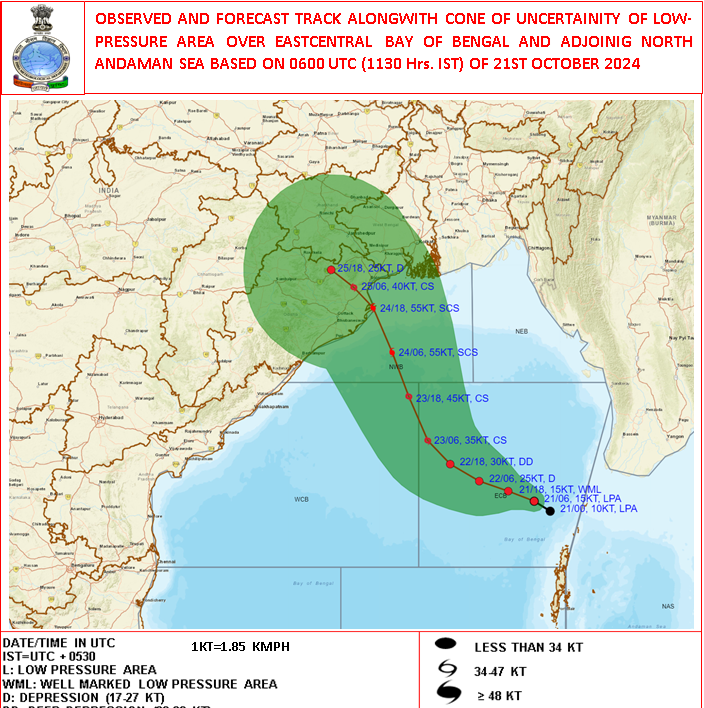
Bhubaneswar, Oct 21: The India Meteorological Department (IMD) has issued graphics indicating that a severe cyclonic storm may make landfall along the north Odisha coast. While the exact location of the landfall is yet to be confirmed, the storm is expected to develop into a severe cyclonic storm by October 24.
IMD Director General Mrutyunjay Mohapatra warned that Odisha is likely to face the full impact of the storm, with high-speed winds of 100-120 km/h and heavy to very heavy rainfall. The storm is projected to remain over the Odisha coast for an extended period, intensifying its impact.
The cyclonic circulation that developed over the Andaman Sea has now intensified into a low-pressure area. It is expected to evolve into a depression by the morning of October 22 and a cyclonic storm by October 23, affecting the Odisha-West Bengal coast.
According to the IMD, the system is forecasted to move northwest towards the coast and reach the northwest Bay of Bengal by the morning of October 24. It is likely to cross between Puri in Odisha and Sagar Island in West Bengal between the night of October 24 and early morning of October 25 as a severe cyclonic storm.
The IMD has also predicted widespread light to moderate rainfall in Odisha starting October 23. Heavy to very heavy rainfall is expected in some areas on October 24-25, with isolated places experiencing extremely heavy downpours.
Powered by Froala Editor
