Cyclone Dana to intensify, red alert issued in Odisha
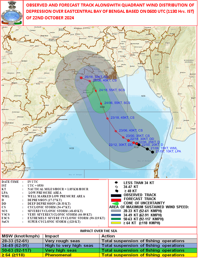
Bhubaneswar, Oct 22: The depression over the east-central Bay of Bengal has moved west-northwestward at 6 kmph and was centered in the same region at 8:30 AM on Tuesday. It lies about 700 km southeast of Paradip (Odisha), 750 km south-southeast of Sagar Island (West Bengal), and 730 km south-southeast of Khepupara (Bangladesh).
The system is likely to intensify into a cyclonic storm by Wednesday over the east-central Bay of Bengal and further strengthen into a severe cyclonic storm by Thursday morning. It is expected to cross the coasts of north Odisha and West Bengal, between Puri and Sagar Island, between Thursday night and Friday morning, with wind speeds of 100-110 kmph, gusting to 120 kmph.
Manorma Mohapatra, Director of the Regional Meteorological Center in Bhubaneswar, warned that weather conditions will begin to deteriorate from Wednesday evening or night under the cyclone’s influence. The sea will remain rough, prompting the issuance of danger signal number 1 at all ports. Fishermen have been advised not to venture into the sea until Friday.
Heavy rainfall is expected from Wednesday night, especially in Bhadrak, Balasore, Jagatsinghpur, Kendrapara, Jajpur, Puri, Ganjam, and Khordha.
A red alert has been issued for Thursday in districts including Mayurbhanj, Bhadrak, Balasore, Kendrapara, Jagatsinghpur, Jajpur, and Cuttack, warning of heavy to very heavy rainfall. An orange warning has been issued for Puri, Ganjam, Khordha, Nayagarh, Keonjhar, Angul, and Dhenkanal, indicating moderate to heavy rains.
Powered by Froala Editor